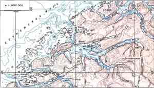
Geographic methods. Map location and measurement
The map is the distinctive data bank of the geographer. Since geography deals particularly with locations, distributions, areal associations, and interrelationships of phenomena in space, accurate observation and measurement of the surface of the Earth and the recording and displaying of location on maps are of prime importance.
Latitude and longitude are commonly utilized for plotting locations on the surface of the globe. Fairly accurate measurements of latitude were made in antiquity by Greek scholars. Measurements of longitude remained rough1, however, because of the difficulty in measuring differences in solar time (the Sun “moves” westward at the mean rate of one degree each four minutes). The perfection of the chronometer solved this problem, but for long each country had its own system for numbering the meridians. Finally, by an international agreement reached in 1884, an imaginary line from pole to pole through Greenwich, near London, was recognized as the prime meridian. Measurement of direction, was aided considerably by use of the magnetic compass, but as Christopher Columbus noted in crossing the Atlantic, the direction in which the compass pointed varied with longitude.
The measurement of distances overland could be counted in days of journey on foot, by camel, by horse, or by other means. More accurate measurements of short distances were obtained by using a chain2, and the chain as a unit of length (66 feet) is still a traditional surveying measure in English-speaking countries. Later, the chain itself was replaced by a steel tape, and still later electronic instruments came into use. A practical measurement of distances at sea was developed in the 16th century: a log3 was thrown overboard and the amount of time it took the stationary log to play out a certain distance on a line marked off with knots4 was measured. Navigation by means of satellites is now available, but a ship’s speed is still measured in knots and records are kept in a logbook5. After the adoption of the metre as a standard unit in France in the late 18th century, it gradually replaced older local and national measures of distance over much of the world during the 19th and 20th centuries.
Maps of small areas – topographic maps, for example – can be made by a method called triangulation6. A base-line is measured with chains or other devices, and by using this base as one side of a triangle the other sides are calculated from the angles at the two ends of the base-line. Angles can be measured more easily and accurately than distances, and from the points on the corners of the original triangle, a network of points joined by triangles can be established. Triangulation was known to the ancient Egyptians and Greeks; with improved instruments, especially the theodolite, this method was utilized in the great national surveys of Europe and America from the 18th to the 20th century. How to represent the entire, spherical Earth or large areas of it on maps remained a problem. In 1492 the German navigator and geographer Martin Behaim completed the construction of a terrestrial globe. Ships following straight lines on flat maps, however, did not arrive at expected points. Mercator devised a map projection – which became known as the Mercator projection – on which ships following straight lines would arrive at the plotted points7. Modern geographers use maps drawn in what is called the equal-area projection, but even this projection distorts shapes or distances, particularly toward the edges of the map.
With the inceasing specialization of knowledge, measuring the shape of the Earth developed into the discipline of geodesy. Plotting land positions for detailed maps became the province of surveying, and constructing numerous types of maps with appropriate projections grew into the field of cartography. Maps have remained as the basic tools in geography for plotting and analyzing a vast range of physical, biologic, historical, economic, political, and social data.
The Round Earth on Flat Paper
Geographers use a variety of tools to carry out their work. The tools that most people identify with geography are those that are still most important to geographers today – globes and maps. Modern geographers, however, also use tools such as aerial photographs, satellite images, and computer programs to help them analyze the interactions between people and their environments. The best tool to use often depends on the geographic theme that is the focus of the research. Globes and maps are useful models of the earth. However, globes and maps do not provide perfect representations of the earth. Each has specific advantages as well as disadvantages.
Globes. The most important advantages of globes relate to their shape. A globe is the only model of the earth in the shape of a sphere, just like the earth. A globe, then, provides the most accurate representation of the shape of the earth. Because it is true to scale, the landmasses and bodies of water the globe illustrates have the same shapes as they do on the earth’s surface. When you look at Greenland on a globe, for example, its true shape is what you see. You can also compare its size to any other land body. In addition, a globe accurately represents the earth’s grid of parallels and meridians, as well as direction and distance from one place to another.
One of the disadvantages of globes is that they often are not practical to use. Globes are expensive and most are too big and bulky to carry around. In addition, people can view only one-half of a globe at a time. This makes it impossible, for example, to look at Canada and India at the same time because they lie on opposite sides of the globe, just as they lie on opposite sides of the earth. Another disadvantage of globes concerns the problem of detail. Because globes represent the entire earth, the individual areas that they illustrate are relatively small. As a result, globes cannot show the detailed features of an area, such as roads, streams, forests, and parks.
The oldest preserved globe is kept and displayed to the public in a museum in Germany. This wooden globe was made in 1492. It is 15 cm in diameter. The globe maker drew on it the land and water bodies that he thought existed. What is interesting about this globe is that it shows the world as Columbus thought of it.
Maps. Maps are flat representations of the earth. Maps vary in size from small maps that appear in pocket size to huge wall maps. Maps also vary in purpose.
One of the most obvious advantages of maps over globes is that they are more convenient to use. Maps can be rolled and folded and are easy to carry around. Maps and related material can also be collected in an atlas to provide an easy-to-use reference. Another advantage of maps is that they can show all of the earth’s surface at one time, or can show specific details.
Maps also can present information about a wide range of topics related to both the physical and cultural features of the earth. Using different colors and symbols, maps can illustrate many kinds of topics, including rainfall, mineral resources, and religions. Presenting such a variety of information about an area often helps geographers to see regions and relationships otherwise difficult to visualize.
On the other hand it is impossible to accurately show a three-dimensional object like the earth on a flat, two-dimensional map. For this reason all maps have one or more inaccuracies, called distortions. The problem of distortion remains the major disadvantage of maps.
Дата добавления: 2021-10-28; просмотров: 784;
Поиск по сайту
Публикации по технике и механике
Публикации по биологии
Публикации по информатике
Публикации по строительству
Публикации по физике
Публикации по химии
Публикации по электронике

Публикации по искусству
Публикации по географии
Публикации по медицине